


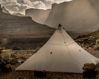
In July, I had the privilege of traversing Idaho’s White Cloud Mountains with Kula Cloth Founder Anastasia Allison. During the months leading up to the trip, I poured over my map of the area, linking together a beautiful route of my own creation.
Looking at maps and imagining ways to travel through terrain is simply one of my favorite things. It’s what drew me to packrafting — at the water’s edge, inflate a boat and just keep going. And it’s what drew me to adventure racing, a sport that’s not only involves a mix of activities — trekking, mountain biking and boating are the staples — but also requires the exclusive use of maps, compass and an altimeter for navigation.

And my love of navigating by maps extends to the frontcountry as well. Several years ago, while visiting a friend in Santiago, Chile, I found myself with the entirety of a day to explore the famed city. As my friend headed off to work, I opened a map of the sprawling metropolis — complete with the subway system — and made a mental note of places that looked intriguing. Then off I went.
The day ended up featuring an exploration of a random fish market and wanderings through an off-the-beaten-path museum. It also included more well-known destinations, such as the city center plaza, where old men played chess. I was delighted by all of it.

While I’ve been quick to embrace technology in many aspects of my life — as the co-founder of GGG, I run an e-commerce store from rural Idaho while working with a remote team — I’ve hesitated to let that seep into my time outside.
This is in part because my time in the mountains is my chance to take a break from work, to get away from the dings and buzzes that fill my day. And, it’s also because I don’t want a phone interfering with my relationship to the natural world. I love noticing subtleties — the hue of the clouds, the texture of the earth and the hoot of a far-off owl.
But this approach has its drawbacks too. A couple of weeks ago, while out trail running, I severely sprained my ankle. As I hobbled home in tears, I kept wishing I had my phone to call my husband, so he could come pick me up at the trailhead, avoiding the last mile of road. And, while in the White Cloud Mountains with Anastasia, I found myself re-thinking the idea of using a GPS.
When Anastasia reached out before our trip to get our exact route so she could download it to her GPS app, I was slightly taken aback. A follow up mention of an inReach did nothing to ease my concerns.
All I could picture was being on the Wind River High Route the previous summer and observing people with their eyes down, glued to their phones, using them to guide each and every step. At one point, I wanted to shout at someone, “The pass is super obvious. It’s right up there. Just put the phone away and walk toward it.”

But with Anastasia, I took the ‘each to their own’ approach, keeping my mouth shut and still bubbling with excitement for our rendezvous at the end of a long, bumpy forest service road.
Our White Clouds trip ended up being amazing on truly every level, and also a bit hilarious, at least to me. At every junction and confusing turn, I’d pull out my map and Anastasia would pull out her phone. We’d each pour over our respective devices and then compare notes.
In this way, we wound our way through the limestone peaks and sapphire lakes with ease (minus a few obnoxiously dusty sections of trail and one night of mosquitoes so numerous that they turned the sky from blue to grey.)
I have to admit, more than once I was grateful for the extra layer of certainty that we were on the right track. And, yes, even the inReach ended up giving me a certain peace of mind, knowing we had a way to communicate with the outside world, if it ever became necessary.

Input from Instagram
After this experience in the White Clouds, I began to wonder about other’s opinions on the question of whether to map or to app. So, here at GGG, we posed the question to our Instagram community.

In our super informal, non-scientific Instagrm poll, 81 people voted for map and 96 people voted for app. The follow-up comments proved fascinating, with a lot of folks finding utility in a combination of both.

Nothing wrong with using technology for navigation, but it’s a fool’s errand to rely on such things. — @mtncrusher.
App is primary navigation, quick and easy to see where you are. Map is a backup. — @lonestarultralight
If I can’t find a map, I screenshot the app and print it out, batteries die. — @jonbarton56
Both. Always have a map for backup. — @tbryceryan
Use an app but you still gotta have and know how to use a map and compass. — @csmith_on _the _fly
And, then my personal favorite:
Neither … I get lost. — @elenabrianne
Input from the Experts

As part of my curiosity on the subject, I was interested to know about the possible long-term effects to our brain. A Vox article titled Is GPS Ruining our Ability to Navigate for Ourselves offers some interesting insights.
"I do think GPS devices cause our navigational skills to atrophy, and there's increasing evidence for it. The problem is that you don't see an overview of the area, and where you are in relation to other things. You're not actively navigating — you're just listening to the voice," Nora Newcombe, a Temple University psychologist who studies spatial cognition, told Vox.
The Vox article goes on to say …
Eleanor Maguire of University College London has found that the city's taxi drivers (who are forced to memorize some 25,000 streets as part of an legendarily rigorous licensing test) have significantly larger hippocampi than non-drivers and bus drivers.
This work raised a key question: Were spatially adept people (with larger hippocampi) flocking to the taxi profession in the first place — or was the process of creating a gigantic, detailed mental map of London causing their hippocampi to grow?
Further research by Maguire indicates that it's actually the latter. She tracked 79 aspiring taxi drivers for four years as they trained for the test, and found that the 39 who'd passed saw significant growth in their hippocampi during that period. Failed drivers saw less growth, and a control group of non-drivers saw less still.
This points to a key fact about navigational ability: It can change over time. Newcombe has come to believe that some people's ability to create spatial maps isn't some sort of genetically determined trait like height or eye color, but a skill they must improve through work. People who are "bad" at navigation, she says, simply don't exercise this skill frequently enough.
Piggybacking off of Maguire’s 2011 study, a 2014 study examined the question of whether a smaller hippocampus can lead to age-related dementia. After following 97 subjects for two years, the study concluded:
After adjusting for age and vascular risk factors, hippocampal volume was a significant predictor for mild cognitive impairment and dementia.
The long and the short seems to be that much like exercise, using spatial thinking to navigate builds on itself creating potential long-term health benefits. While the inverse is also true i.e. lose it if you don't use it.
The Verdict

While I won’t be ditching my paper map anytime soon and still get annoyed when I see people glued to their phone in the backcountry, I do now think there’s a time and a place for GPS apps. I view them as sort of a fact checker, a way to confirm that I’m actually where I think I am. While this at times can diminish a sense of adventure, it can also bolster confidence — in both myself and the excursions I choose to take on.
Let’s keep the conversation going! Please leave a comment below with your 2 cents. I’m also quite interested to know people’s navigation apps of choice (for a likely follow up article). In our Instagram poll, Guia and Guthook were mentioned frequently. Do you all use these apps? What other backcountry navigation apps are out there that you love? How about ones you strongly dislike?


9 comments
Todd Nystrom
This is always a topic that stirs debate. I am definitely in the map-as-primary camp and only go without a paper map in places I am very familiar with, that are also not remote or rugged. Between batteries running out, a GPS getting broken (been there, done that) and loss of cell service on a smartphone (places I like best) today’s reliance on electronic technology often gets people in trouble.
I spend a lot of time studying maps and often creating custom maps before a big trip which pays big dividends in familiarity when the boots hit the trail!
I also carry a GPS that I take the time to load with key waypoints and landmarks before a big trip. Setting up the GPS is another way to familiarize myself with a route.
I like your description of the GPS as a fact checker, which is also how I tend to use it on the trail. The other thing the GPS does for me is to help document the trip, mark points-of-interest, and allow me to share those details in digital form afterward.
One final thought for someone learning to navigate in the backcountry is to start with a map and compass, to build confidence, skills, and understanding!
Amy Hatch
Thanks all for your thoughtful comments and responses — and for the app recommendations too. Such an interesting conversation topic and great ideas to further think about.
While I appreciate opposing points of view, I don’t appreciate being belittled and told that I’m just “intellectually offended” and should “suck it up.” Instead, I’d invite a question that would further our understanding of each other and create empathy, such as asking me with sincerity to further explain why it bothers me so much to see people glued to their phones while in the wilderness. I’d be happy to provide some insight, if you genuinely care to know.
Kim Kremer
I LOVE maps. When I was a kid, I’d spend hours absorbing the details of the National Geographic maps we had. I imagined myself floating down the Mississippi River on a raft, guiding Lewis & Clark through the American West alongside Sacagawea, following the footsteps of Shackleton’s overland journey to ‘civilization,’ walking among the ancient streets of the Apostle Paul’s missionary journeys. It probably surprised no one that when I joined the Coast Guard, I became a quartermaster – the keeper of the ship’s charts & navigational guidebooks, charting courses, following lines of our own making.
I still love maps, and I carry a paper map as a backup to the Avenza app on my smart phone. It’s loaded with USGS 7.5 maps that are a larger scale than the paper map I carry. More importantly, I know how to use a map & a compass and I know the limits of my navigational skills in the backcountry. A map is only good as a fire starter if the person carrying it doesn’t know how to read it.
Bernard Palmer
When smart phones came out I stopped using newspapers (saving trees) and getting my information in near real time. It took pointing out to my wife that when my head was buried in a newspaper at the table it was okay, but when I changed over to the phone it wasn’t? I hadn’t changed my practices she’d changed her Expectations. It’s not my choice to go out without a paper and compass for backup and most of the days travels. But is simply seeing people on the trail choosing to utilize their technologies a reason to allow ones-self to become offended? Suck it up and enjoy yourself out there for you, not despite others.
If the opportunity arises and you run across someone who failed to have adequate backup take that opportunity to educate and assist or take it as comic relief. But don’t let little things others do ruin your day. My smart phone has so many use. Plant identification, momentary light source, book with no added pack weight and much much more. There is fun in finding ways to keep them charged too. Wasted cooking heat, solar, body movement, wind, micro waterwheels. Let’s all try to be a little more tolerant in reality and not just be intellectual offended.
GGG is all about new and improved.
Nancy
Great topic and article, Amy. For the first time in 50 years of hiking, we used (and were very grateful to have) All Trails from my phone while also using a map and compass to get in and out of the Bistie Badlands Wilderness. At times when we were confident with the map, All Trails reversed us and we finally found the correct wash to hike. Amazing. !
Todd
Map 1st. Old eTrex 10 with trails loaded as backup. Sometimes I use the eTrex just for tracking to review when home to see how slow I’ve become! I do like the GPS to mark water.
John Davis
I use gaia and guthooks for well maintained trails. Distance to next potential water/vamp spot. Elevation gain expectations visually. Bit a map is to a cigar as app is to vaping pineapple. Maps are cerebral, apps act as shortcuts to what we already think. And that is always that its a mile or mile and half to the next thing!
Steven Parker
As a trail maintainer, I use apps more for logging issues (like a tree across the trail) rather than navigation. Having gps coordinates and a linked photo helps the trail crews know what to expect. App of choice is AlpineQuest, though it’s only available on Android, because of the number of base maps available.
Drew Boswell
This – “…eyes down, glued to their phones, using them to guide each and every step…”
Yep. There’s a difference in a tool that makes the outdoors more enjoyable and safe, and a portal which restricts your experience to one dimension. GPS navigation for me is an occasional check a few times in a day. Otherwise, I’m just walking and looking around. But I see so many people whose outdoor experience seems to be completely mediated by their screens. That looks like dependence to me. The same screen-gazing lifestyle is prevalent in more than just hiking, to the point that I wonder what we’re doing to our brains.